The CSD Education Team partnered with the Earth Institute's the Center for International Earth Science Information Network (CIESIN), as part of their Geo-Referenced Infrastructure and Demographic Data for Development (GRID3) initiative to conduct qualitative research to identify ways in which Nigerian education sector leaders from federal, state, and local levels envision using geospatial data to support their policy and planning decisions.
Image Carousel with 31 slides
A carousel is a rotating set of images. Use the previous and next buttons to change the displayed slide
-
Slide 1: GRID3 Education Use Case Baseline Study Preliminary Findings
-
Slide 2: Education Baseline Objectives
-
Slide 3: Research Questions
-
Slide 4: Methods
-
Slide 5: Participants
-
Slide 6: Presentation of Use Cases
-
Slide 7: Use case #1
-
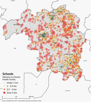
Slide 8: Use case #1 Maps
-
Slide 9: Use case #2
-
Slide 10: Use case 2 maps
-
Slide 11: Use case 3
-
Slide 12: Use case #3 maps
-
Slide 13: Use Case #4
-
Slide 14: Use case #4 maps
-
Slide 15: Findings: Ed Planning Process
-
Slide 16: Findings: Ed Planning Priorities
-
Slide 17: Findings: Education Priorities
-
Slide 18: Findings: Education Challenges
-
Slide 19: Findings: Education Challenges
-
Slide 20: Findings: Education challenges
-
Slide 21: Findings: Geospatial mapping benefits
-
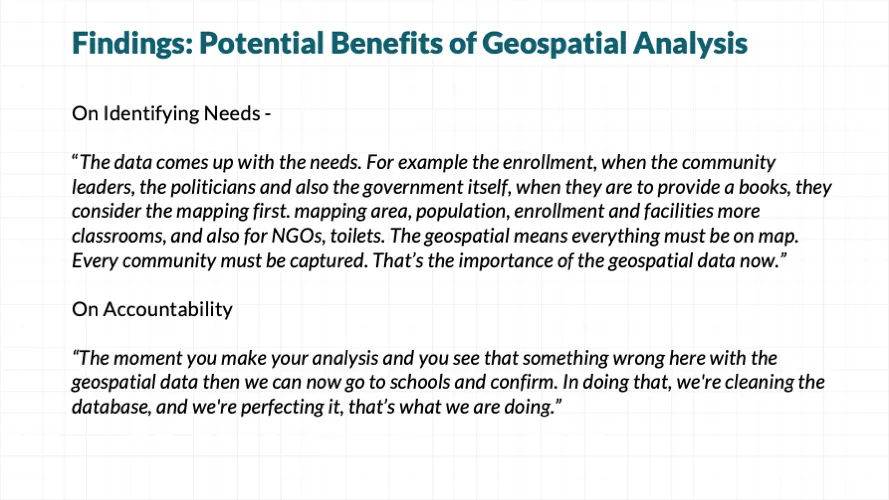
Slide 22: Findings: Potential benefits of geospatial analysis
-
Slide 23: Findings: Geospatial mapping prioririties
-
Slide 24: Findings: Geospatial mapping prioririties
-
Slide 25: Findings: Geospatial mapping prioririties
-
Slide 26: Next Steps
-
Slide 27: Maps
-
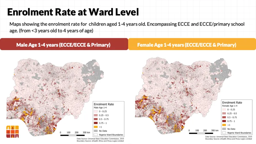
Slide 28: Maps - enrolment rate ward level
-
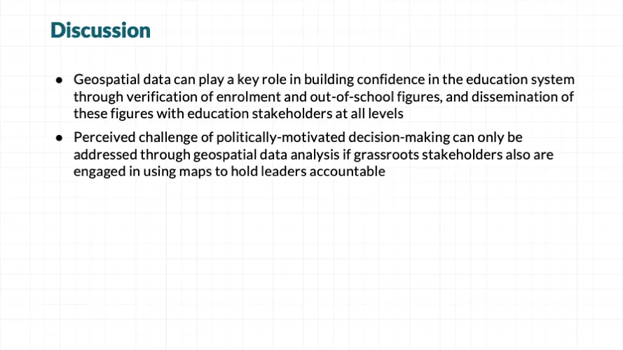
Slide 29: Discussion
-
Slide 30: Ed Team Contact
-
Slide 31: GRID3 contact


Since countries of the world adopted the 2030 Agenda for Sustainable Development, along with its 17 Sustainable Development Goals (SDGs), 169 specific targets, and 232 indicators across a broad range of interlinked sectors, there has been extensive global dialogue on defining of the SDGs, how to implement them, and the role of data-driven decision making in that process. Yet there has been less focus on the critical role geospatial information can play in monitoring progress and targeting solutions to the geographic areas that need them most urgently.1 Even with an abundance of data available, for data to be useful in decision making, stakeholders must have direct access to training and tools that make analyzing and using data easier, and must foster a culture of data use and teamwork.2
It has been estimated that as many as 20% of the SDG indicators can be measured using geospatial data – either alone or integrated with statistical data. Ideally, foundational geospatial datasets, such as settlement, transportation network, and population data, could be collected nationally to underpin SDG indicator calculations, however there exists great differences among countries’ capacities for consistently generating high resolution geospatial data.3
In Nigeria, stakeholders from federal to the Local Government Area (LGA) levels have, over the past decade, made significant strides in building local capacity to use geospatial data in making data-driven decisions for education. CSD’s Director of Education, Radhika Iyengar, describes in her 2015 article the process of developing the Nigeria Millennium Development Goal Information System (NMIS) through an initiative of the Office of the Senior Special Assistant to the President of Nigeria on the Millennium Development Goals, spanning from 2011-2013. While their experience building capacity within the education sector to collect real-time geo-located data and analyze it using geospatial tools demonstrated the great potential of data-driven decision making in education, it also demonstrated that such progress requires intensive and ongoing training and support to inculcate the cultural shift to data driven planning and decision making. Such a culture also requires data to be easily available and understandable, i.e. through online data visualization tools that local data managers can maintain. In Nigeria, there is plenty of education data available through the Education Management Information System (EMIS), but the degree of effort put into collecting data is not matched by effort and funding put into utilizing that data to drive decision making.5
In 2019, the CSD Education Team partnered with another center of the Earth Institute, the Center for International Earth Science Information Network (CIESIN), as part of their Geo-Referenced Infrastructure and Demographic Data for Development (GRID3) initiative to identify ways in which Nigerian education sector leaders from federal, state, and local levels envision using geospatial data to aid in their policy and planning decisions.
Qualitative data including surveys, interviews and focus group discussions were conducted over the course of a 3-day workshop in Abuja, Nigeria in June 2019, attended by 30 key education stakeholders from Kaduna, Adamawa and Gombe States, to discuss their decision making processes, use of data and the role of data in their decision making, the challenges they face in using data for decision making, including any data availability gaps, and staff capacity for data-driven decision making.
Within a Social Assessment framework, which Rietbergen-McCracken and Narayan (1998, p. 19), define as a process that “provides a framework for prioritizing, gathering, analyzing, and incorporating social information and participation into the design and delivery of development operations”, the two-day workshop itself was designed to first present the premise and guiding questions for the workshop, which included:
- Are current educational practices in compliance with policies at the state and federal level?
- How can data inform policy planning and implementation monitoring?
- Effective pathways to meet the Sustainable Development Goals (SDGs) are based on strategic inter-sectoral linkages. How is the education sector supported by other sectors, such as health?
Participants were presented with a series of education research questions along with use cases demonstrating how geospatial data could be used to help answer them. The use cases were developed by CIESIN with input from the CSD Education Team based on their experience implementing education programs in sub-Saharan African countries. Participants then discussed how other relevant policy scenarios could be visualized using geospatial data. Participants also discussed how their institutions could support the mapping of identified scenarios through harmonization, provision, and/or collection of additional data if necessary. Based on these identified scenarios, stakeholders were asked to think of key policy issues to prioritize for mapping of geospatial data and to develop action plans for enabling the data mapping in order to use it in their decision making over the next year.
As evidenced by the qualitative data brought forth through the workshop discussions, interviews, and focus groups, geospatial data has the potential to play a key role in building confidence in the education system through verification of enrolment and out-of-school figures, and dissemination of these figures with education stakeholders at all levels. While discussed outright in many instances, the undercurrent woven through many of the responses was that geospatial data can help overcome the pervasive problem of data unreliability, often caused by what is perceived as politically-motivated decision making at various levels, by using geospatial data for validation. It is worth noting that the current assumption of unreliable data will be difficult to overcome, even as data becomes more reliable and transparent, due to education officials becoming jaded to this challenge over many years working in the sector. Consistent availability of geospatial data for all relevant stakeholders and its consistent use in decision making must continue over time to eventually minimize this overwhelming concern of data being unreliable.
The research questions and corresponding use case maps, along with a summary of key findings, are presented in the slides linked below, which were presented during a side-event to the 2019 United Nations General Assembly.
References:
1. Scott, G. & Rajabifard, A. (2017) Sustainable development and geospatial information: a strategic framework for integrating a global policy agenda into national geospatial capabilities, Geospatial Information Science, 20:2, 59-76, DOI: 10.1080/10095020.2017.1325594
2. Dunlap, D. M., & Weber, R. E. (2009). When data are insufficient to make group decisions: A case study in community college administration. In T. J. Kowalski and T. J. Lasley II (Eds.), Data-based decision making in education (pp. 441- 454). New York: Taylor & Francis.
3. Arnold, A., Chen, J., Eggers, O. (2019). Global and Complementary (Non-authoritative) Geospatial Data for SDGs: Role and Utilisation. United Nations.
4. Iyengar, R., Mahal, A., Felicia, U., Aliya, B., Karim, K. (2015). Federal policy to local level decision-making: Data driven education planning in Nigeria. The International Education Journal: Comparative Perspectives. Vol 14, No 3, 2015, pp. 76-93 https://files.eric.ed.gov/fulltext/EJ1086809.pdf
5. Iyengar, R., Mahal, A., Aklilu, L., Sweetland, A., Karim, A., Shin, H., Aliyu, B., Park, J., Modi, V., Berg, M., & Pokharel, P. (2014) The Use of Technology for Large-scale Education Planning and Decision-making, Information Technology for Development, DOI: 10.1080/02681102.2014.940267 https://www.researchgate.net/publication/271931421_The_Use_of_Technology_for_Large-scale_Education_Planning_and_Decision-making